Saturday, 20 April 2024 12:42 PM
OR
Login using
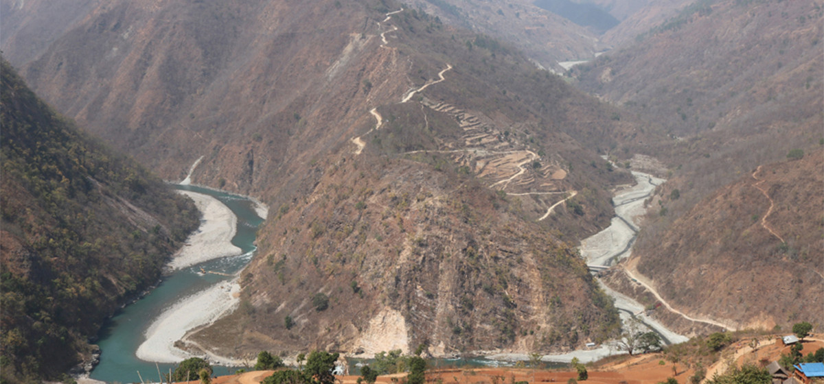
Karnali Corridor Highway, the way to Karnali’s prosperity, on track
Published On: January 24, 2017 04:25 PM NPT By: Kiran Bhattarai
KALIKOT, Jan 24: With the works on opening the track of the Karnali Corridor Highway gearing up, hopes have risen that one of the remotest corners of the country – Humla district in the far northwest – would get connected to the national road network.
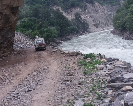
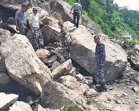
The opening of track of the 196 kilometers road stretching from Lalu VDC in Kalikot district to Simkot of Humla district is underway at full steam, courtesy the Nepalese Army. It is an arduous task constructing the track on bare rock cliff, vertical slopes and the narrow gorge at numerous places along the Karnali River.
This road has been considered significant for the overall development of the Karnali region for it will work as the lifeline for the remote parts of the Karnali and Seti zones. Moreover, this road will be the main artery running from Hilsa in the northern border with Tibet to the Jamunaha border checkpoint on the border with India to the south.
It is also a national pride project. The completion of this road project will make travel to the holy site Kailash Manasarovar in Tibet easier, which is expected to boost tourism.
The Army has already opened 50 kilometers track of the total 145 kilometers that it has been assigned for. Of the 50 kilometers track, 22 kilometers falls in Kalikot district while 28 kilometers in Bajura district.
The Army is carrying out works to open further 20 kilometers track at Ratadanda in Kalikot and Kalabhir and Rupakhola in Bajura district, said Brigadier General Uddhav Bista of the NA’s Infrastructure Construction Directorate. The Army plans to open 40 kilometers track in Kalikot within the Fiscal Year 2017/2018 and hand it over to the Department of Roads.
The government had assigned the responsibility of opening track of the Karnali Corridor Highway to the Army in April 2015, describing this road as a special condition road. Of the total 196 kilometers road, the Army will construct 145 kilometers up to Sarisalla, Humla.
The remaining 51 kilometers of the road would be constructed by The Department of Roads.
Presently, 182 army personnel and 300 locals have been working on the construction of the track of this important road.
The road has been divided into Khulalu-Laifu-Simkot section. Forty kilometers of the road section lies in Kalikot, 43 kilometers in Bajura and 113 kilometers in Humla. In the view of al Bahadur Bista of Bajura, construction of this road will not significantly contribute to the development of Karnali zone but also to the development of the Far-west region.
Eight major bridges have to be constructed on this highway – one each over the Khulalu Khola, Sannighat, Fugad, Bhakka, Juddigad, Kunda and Kawadi streams that join the Karnali river. The width of the road is six meters and no physical structures shall be allowed to be constructed on 7.5 percent of the road on both sides. This will provide room for any future widening of the road.
The starting point Khulalu lies at an altitude of 730 meters from the sea level and the road climbs up to Simkot at an altitude of 2945 meters from the sea level. The estimated cost of the project is Rs 2.841 billion.
The Army spent Rs 220 million on road construction last fiscal year and Rs 210 million has been allocated for this purpose this fiscal year.
Last week, Defense Minister Bal Krishna Khand together with the Minister for Physical Infrastructure and Transport Ramesh Lekhak and Minister for Poverty Alleviation Hridayaram Thani inspected the road construction works going on at Piluchaur of Bajura and Shilajit Bhir in Kalikot. On the occasion, the three ministers pledged the necessary cooperation from the government side for the construction of this road.
They said the road construction would not be halted for lack of necessary budget and that the government was ready to provide extra budget apart from what already has been allocated.
So far, five people including one army personnel have lost their lives while constructing the road – falling off the cliff, said Lieutenant Colonel Indibar Gurung of the road construction taskforce. He said the terrain where the remaining portion of the road has to be constructed consists of hard rock and there is further complication owing to the houses and structures in human settlements lying along the alignment of the road.
Khulalu, Rengil, Sannighat, Kaprigaon, Piluchaur, Arthangechaur, Boldhik, Kawadi, Makaigaon, Tumchagaon, Sarisalla, Sarkigad, Laligaon, Kharpunath,Baragaon and Simkot are some of the settlements lying on the road alignment.
It is also said that there is difficulty transporting construction materials as ferries cannot be operated on the Karnali river in the rainy season, although ferries are operated in the winter.
Director General of the Department of Roads, Devendra Karki said the Department will also carry out works like black-topping the road and construction of bridges simultaneously with the construction of the track.
The Karnali Corridor road meets the Karnali highway at Kalikot. The Karnali highway from Surkhet to Jumla is 232 kilometers and asphalted. With the completion of the Karnali Corridor highway, will complete the 530-kilometre north-south road from Hilsa, the northern border transit point in Humla to Jamunaha, the southern border transit point in Banke district.
The Nepalese Army is vigorously working to connect Dolpa district to the national road network within one year and Humla within two years, pursuant to the government’s policy of bringing all the district headquarters in road connectivity.
The Army has constructed 106 kilometers of the 118 kilometers Bheri Corridor road that links Dolpa district headquarters. RSS
You May Like This
Army opens 66 km track in Karnali Corridor
KALIKOT, Jan 2: Construction of the Karnali Corridor has seen a remarkable progress since the Nepal Army (NA) took over... Read More...

11 killed in bus accident in Karnali highway
DAILEKH, June 14: At least 11 passengers have died in a bus accident in Karnali highway near Nayan Mandir of... Read More...
Army clears obstructions at Karnali Highway after 4 days
KALIKOT, July 23: Nepal Army (NA) has cleared obstructions along the Karnali Highway caused by landslides at Kalikot district on... Read More...


850 grams of gold seized from Indian national at TIA
21 hours ago

_20220508065243.jpg)


Just In
- 352 climbers obtain permits to ascend Mount Everest this season
- 16 candidates shortlisted for CEO position at Nepal Tourism Board
- WB to take financial management lead for proposed Upper Arun Project
- Power supply to be affected in parts of Kathmandu Valley today as NEA expedites repair works
- Godepani welcomes over 31,000 foreign tourists in a year
- Private sector leads hydropower generation over government
- Weather expected to be mainly fair in most parts of the country today
- 120 snow leopards found in Dolpa, survey result reveals
Leave A Comment